Oregon 800 Part 1: Northbound
“Crap, we forgot the salami and cheese!”
Can the sun shine like salami if you forget the salami? 
- 740 miles
- 19 days
- 4 national forests
- 1 state
Part 1: Northbound, Klamath to McKenzie River, days 1-10
Our original plan for the summer of 2021 was to ride the Oregon Timber Trail (California to Washington borders). Unfortunately, a major section of the trail remains closed from the Lionshead Fire in 2020, with no viable reroute. After evaluating alternative routes in Oregon or Idaho, getting depressed over our potentially failed trip, and trying to get creative with re-routes to make it all happen, we eventually had an ah-ha moment to combine the point-to-point OTT and Oregon Cascades Volcanic Arc routes with a few creative connections to form what we’re coining “The Oakridge 8” loop. With the start/finish in Klamath Falls, we could stay with Adam’s aunt in Ashland and forget our salami in her fridge when she drops us at the start. It’s nice when a plan comes together. 


 Passing the first OTT signs of the trip, we made good time to Bear Creek, our first water stop. On the map it looked like this would be our only water stop for a while, so we drank deeply and loaded up on water to continue the climb.
  The extent to which the land owners secure their fences is worth noting. This stretch of trip had at least a cumulative hour trying to figure out how to unfasten, move, and refasten barbed wire fences. These cows are definitely not getting out (and a few times we thought we might not get in)!

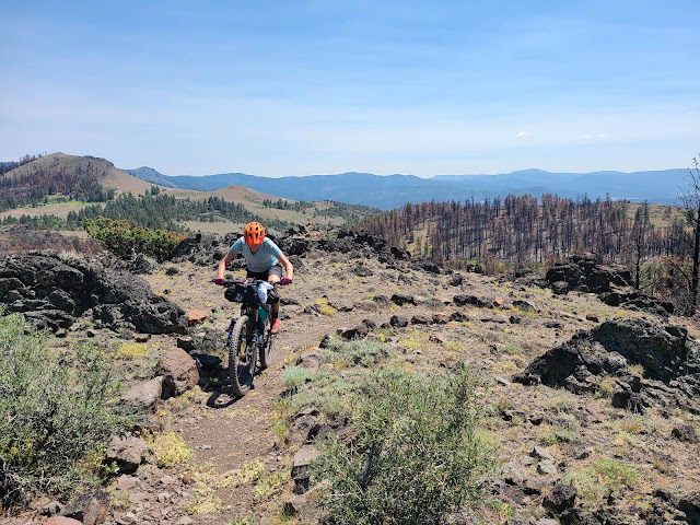
 This was Adam’s least favorite stretch of trails on the trip, and one of Ana’s favorites. Sometimes it’s best to agree to disagree. It really is a site to see.


 Begging for mercy and appealing to her sense of reason regarding the distance to the next water stop, Adam convinced Ana that they should skip the final stretch of Winter Rim and detour on the fireroad instead. We were eager to get on the trail, as we wouldn’t be ending the day with a scrub in a creek and a bag of rehydrated food. Tonight we would be freshly showered and dining at the Cowboy Dinner Tree and sleeping in a real bed. More on that in a bit. On our fireroad detour we got a brief view of an antelope as it sprinted by us before we rejoined the trail and descended away from Winter Rim and toward the Cowboy Dinner Tree. As the crow flies it would have been a quick straight shot to Cowboy, but our route included a detour to climb Hagar Mountain so that we could get in some quality hike-a-biking to work up an appetite for dinner. What Hagar Mountain *did* have was an entire hillside of wild lily, which made Ana scream out loud like a kid on Christmas morning.
 With much of the afternoon ahead of us before our 6:00 reservation, we pulled into Cowboy and met the locals.There were no people in sight, but there were friendly kitties and a doggo to keep us company in the shade until someone was able to come and show us to our cabin. In between showering and our improvised laundering (promise we didn't clog any sinks), we met our cabinmates, Bob and Belly. Bob is an extremely friendly black kitty with a bob tail, and Belly who's primary interest was us rubbing his eponymous belly. No, we have no idea what their real names are, but they were most certainly the best cabin cats ever.


 Day 5 was another good day for eating. Steak and (rehydrated) scrambled eggs for breakfast and chicken and potato wraps for lunch, thanks to leftovers! And thanks to Susan for suggesting we ship ourselves aluminum foil in our resupply box to make said wraps to-go. The hosts of the CDT were gracious enough to receive a package for us, which we shipped before leaving on the trip, and contained our next 4 days of food, and the scrambled eggs for breakfast. Yes, this was very pre-meditated eating. The day was going so well until Adam had a rock bounce up into his rear wheel, snapping a spoke and puncturing his rim tape, deflating the tire.


 Water concerns were minimal, and though it took us longer than expected (it always does), we made it to the top of Yamsay Mountain! This was literally the high point of our trip at 8,200 ft., and also the spot where we got to check two more boxes off of our bikepacking bingo cards: Adam got a bloody nose and Ana crashed. And, after all that hard work, the descent from Yamsay Mountain was such a let down. An old decommissioned access road turned “trail” with a thousand water bars and endless sand pits took us to a fireroad descent, squandering all the elevation we gained climbing that sweet, sweet singletrack. But, over an 800 mile route, there's bound to be some disappointment. Finding a campground we could have to ourselves with a nice creek was a small boon at the end of the day. You take what you can get.
 Day 6
Day 6 But first: more lakes! We found a new lake around every bend in the trail as we flew down the trail in our head nets, trying to stay ahead of the mosquito swarms. As we looped around the stunning Summit Lake we saw a PCT hiker packing up, one of the first trail users we’d seen in a week of riding. Shortly thereafter a Harley Davidson rider drove toward us on the rugged dirt road. Must have been an Apple Maps beta tester. After a brief backtrack due to Adam spending more time daydreaming than navigating we were at Timpanogas Lake, the source of the Middle Fork Willamette River and the start of our 30 mile descent to Hills Creek Reservoir and Oakridge beyond.
  We had a hotel room booked in Oakridge the following night, but our plan was to push all the way to town a day early to book a room and have the following day free to get Adam’s wheel repaired and finally have a rest day. The handful of downed trees we had to cross on the way to Timpanogas slowed us down, but we had reached the point where our mantra would become reality. Grinning ear to ear, we started down Middle Fork. Then hit another down tree. And shortly thereafter a few more.
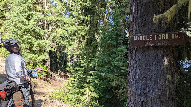

 Turns out, when faced with a truly impassable pile of collapsed giants it can be used to saw a tunnel out of the branches to squeeze through a low point. Bonus points if you’re still wearing a mosquito head net while carving the tunnel.


 After far too long spent on far too few miles, the trail crosses Forest Road 21, a paved road that parallels the trail the rest of the way to town. With no idea whether or not the carnage continued on the other side, we made the decision to jump on the road for a bit before rejoining the trail 9 miles down, hoping that trail fairies had cleared the trail further down. We got 6 sweet miles of swoopy river singletrack with not a downed tree in sight before a poorly signed reroute (and old GPS file) left us following the old trail that had recently been decommissioned. Overlooking a field of downed trees in a creek threatening to trigger our PTSD, we turned around and headed back to the road, skipping the final 9 miles of singletrack and riding pavement all the way to Oakridge. The two priorities when we finally reached town were finding a place to get dinner and calling the hotel to get a room for the night that would carry over to the reservation the following night. Adam was on food duty at the BBQ food truck while Ana sorted hotel logistics. Sammies acquired, he returned to terrible news: the hotel was booked for the night. Shit. Now what? Sure we could camp a few miles outside of town, but we had so many things to do in town the next day, that seemed like a logistical nightmare, on our one and only rest day. On the way into town we had passed a motel with a bike friendly sign.
 Crossing our fingers, Ana called The Arbor Inn and was able to reserve a room with space for our bikes and laundry facilities. We were even able to cancel the other reservation and book a second night at the Arbor so we wouldn’t have to shuffle our stuff across town. And the hotel was great! That will teach us not to judge a motel/RV park/storage facility by it's cover. The woman working that night was so friendly and accommodating, the room was spacious and clean, AND had a kitchenette with stove and fridge, and was even close to the bike shop! A great base camp for our mini-break in the trip. The only thing better than having a real bed was being able to do real laundry!

After the morning rush at the shop had mellowed out, we were able to start chatting with another mechanic, Olivia, about the amount of trees down on Middle Fork and our plans for the coming week. We learned that she’s one of the sawyers that helps clear the trails and is friends with the person responsible for clearing the trails. Unrelated to our trip, the Oregon Timber Trail was hosting their first race, the OTT 700, and the riders had started their north-bound trek on the trail just a few days after us. This meant they were headed straight for the downfall that we spent the entire day battling. The sawyers were going to do their best to get out there to clear it out before the OTT racers came through, but because of a late snowmelt, followed by a sudden warm and dry fire season putting chainsaw restrictions in place, they hadn't had the normal window to clear trails up that high, and they were simultaneously restricted to only sawing for a few hours in the morning. They must be some sort of magicians, because they were able to get the entire section of the Middle Fork cleared out by the following day! This was only slightly bittersweet news for us given the nightma... character building of the previous day, but overall we're glad no one else had to endure that kind of torture.
Talking with Olivia and Heather at the shop was also when we revisited the idea of reversing our next section of the route; heading north toward McKenzie Bridge rather than east up Bunchgrass. Marcello interrupted to make sure Adam would be okay with a non bladed spoke...and regretfully informed him that they didn’t have any purple nipples to match (which is a bike part, for any non-cyclists making a face right now). While it would have been reasonable to call the whole thing off at that point, Adam agreed that that would be fine. We dropped supplies back at the hotel and let them finish off the bike, then came back to close out. This may be the only time Adam’s negotiated up the quoted repair costs. You can’t help but smile when working with Marcello and Olivia; we could have spent all day hanging out at the shop with them.


Day 9
Our running around the day before included picking up a breakfast burrito from Stewart’s 58 (thanks for the tip, Marcello!), and ordering a deli sandwich from the grocery store to carry with us for lunch the next day, all kept safely overnight in the hotel fridge. Seriously, Arbor Inn for the win. A big breakfast was called for, as we had a lot of climbing on the schedule. Before we left town, we wanted to get a picture fully loaded in front of the Mercantile. We headed over well before they open, started to pose for the ‘gram, and suddenly the door swings open and Marcello pops his head out! He was excited to check out our bikes fully loaded and was happy to take some pictures of us together, and reminded us that we were crazy as we rolled out of town yelling, "See you in five days, we hope!" We’ve always had great experiences at the Willamette Mountain Mercantile on prior trips to Oakridge, but now they feel like family. We couldn't wait to get back into town after our northern loop.

Fond farewells completed, it was time to climb out of town and roll through the OHV zone and take a quick spin on the moto warm up loop before dropping back down to the Willamette River to begin the climbing in earnest.


 Eventually the pavement came to an end but the climbs stayed manageable, and we even stopped for a hike at Flagstone Peak, a sport climbing spot with a bunch of routes. It was another hot day, but the stops for dunkers in the creeks and the tree cover kept us from overheating.
 We eventually descended to Cougar Reservoir, hoping to avoid a repeat of our experience on Bear Creek. Terwilliger Hot Springs was down the road, but it didn’t sound very appealing with the temp hovering around 90 and smoke from a fire starting to blow in. We circled around to Slide Creek Campground, found a site, and headed down for a dip to cool off before dinner.


 Our first stop of the day would be the Blue Sky Market to pick up some snacks and maybe second breakfast. Our route to the store included crossing Cougar Dam (the tallest in Oregon), and descending the 519 foot height down to the McKenzie River Valley below. Ana picked up some semi-decent gas station coffee and a pastry, Adam found some coffee cake, and we both found some non-bar shaped snacks for the day. Pastries were consumed while making use of the spot of cell service to check for fire and smoke updates before we got to the base of the McKenzie River Trail.


It was just a short couple mile road burn to the trailhead, but right as we were about to jump on dirt we realized we missed a critical activity while we had cell service. Standing on the side of the highway with minimal cell reception isn’t ideal for trying to call and make a hotel reservation, but we managed to snag one of the last rooms available at the Arbor Inn on our expected arrival date in 5 days. We even got the same room again!


 We eventually arrived at the Blue Pool trailhead, and were pleasantly surprised to see there was a new bike only trail reroute to minimize traffic issues on this busy section of multi-use trail. This was the beginning of our actual elevation gain as well, so not having to contend with crowds of hikers was a welcome bonus. Oregon has a rich volcanic history, and this section winds through jagged outcroppings of unforgiving volcanic rock. The work the trail builders put into this section is incredible, and it would be a blast descending. Climbing it on loaded bikes there were frequent hike-a-bikes to avoid finding out how well the rocks double as a human cheese grater.

When we did, however, we were greeted by multiple “Campground Full” signs. Not Ideal. Ana found the camp hosts and explained our situation, and they were more than happy to squeeze us into a spot, stating they always have room for hike and bike-in campers! We were shown to an unmarked area, just off of another established site. The campers closest to us who had done a great job of maximizing their use of space with a volley ball net and other lawn games for two, were less stoked to see us show up, but we tried to be good neighbors. Even though we were hot and sweaty, swimming was off the table in Clear Lake. The water is snow runoff from nearby mountains and filters through caverns for 20 years (seriously!?!) before feeding into the lake, keeping the temperature between 35-43 degrees. It was almost tolerable for wading. We unloaded our bikes in anticipation of the baggage free spin the following day.

To continue the adventure, days 11-19, go here!
Day 1, July 1
It may be that we forgot about the salami because we were preoccupied with trying to decide where to start the trip. Smoke was blowing in from the Lava Fire on Mt. Shasta and the forecast was calling for temps in the mid to upper 90s. If we started in Klamath Falls as planned, we would have 65 flat, exposed miles in the sun on the OC&E Rail Trail before heading into the forest. We loaded up the car, still unsure of the destination. Suck it up and start from Klamath anyway? Jump ahead to Sprague River, Beatty, or even out to Bly and skip the Rail Trail entirely? Driving into the smoke, we decided the Klamath Falls start wasn’t the best idea, and pushed ahead to Sprague River, chopping 40 miles off the start. We parked, installed the final bags on the bikes, said our goodbyes to Aunt Kimberly and hit the trail!
We didn’t have high expectations for the OC&E, but were glad that it provided a way to connect to the OTT away from roads and cars. We had no idea we’d see so many birds! The Klamath basin is home to multiple wildlife refuges, and its wetlands support a wide variety of birds. We saw two adult and one juvenile bald eagles, sandhill cranes, pelicans, and many other small birds we couldn’t identify. And cows. Tons and tons of very friendly cows!
The temperature was starting to climb as the hours ticked by, but we were granted a brief respite from a large field sprinkler that overshot onto the trail. We may have ridden back and forth through that delightfully cold water a few times. Soon enough we were at the town of Bly, our lunch (and salami) resupply stop. The chicken philly and Indian taco were filling, the berry smoothie with optional fresh frozen fruit was tasty (and good for a laugh), so it was time to head to the market for salami. Unfortunately we struck out at the market, and managed to find some prepackaged meat and cheese slices at the gas station. Good enough!
Back on the bikes, we left civilization behind and turned toward the mountains, stopping at the Mitchell Monument, memorializing the only deaths on American soil during WWII. Japan made balloons with explosives and floated them across the Pacific on the jetstream, and a family found one that landed and it exploded, killing six.
Leaving the monument, we stopped at a creek to dunk our shirts in the water to provide some air conditioning on the ride, and continued on to Happy Camp, our stop for the first night.
(We later found out that a mere 5 days after passing through this area, it was on the southern edge of the Bootleg Fire, which we would spend the rest of the trip keeping a close eye on.)
Day 2
Day 2 started with a 5AM wake up, which would become the standard for most of the trip. It takes us about 2 hours to make breakfast, eat, and pack up, so we were back on the bikes and rolling out of the campsite about 7AM.
We made a quick stop at a nearby campsite to top off on water, then it was time to climb up to our intersection with the OTT (and our first singletrack)! The climb passed quickly and we jumped on the singletrack after a quick gas station salami lunch stop, procured the day prior, and water fill-up from a broken water line. Obscure water stops like this were clearly marked on our map thanks to the leg-work done by the creators of the Oregon Timber Trail.

And then Adam promptly lost his water bottle on a chunky little descent. Tree cover was sparse as we traversed ridges and the air was thin as we flirted with the 7,000 foot elevation line.
A brief respite of shade was found just below the Morgan Butte Fire Lookout, and we had only a 10 mile downhill to the Chewaucan River and our campground for the night. What we didn’t realize is just how long a 10 mile descent can be, navigating burn zones and downed trees in the unrelenting heat. I think this is what they call foreshadowing?
Eventually the trail deposited us directly to an open campsite and we deposited ourselves in the river to cool off and wash the dirt and ash away. Our friendly neighbors gave us a gallon of water to reduce how much we had to filter, and our unexpected neighbor was a crawdad that hitched a ride in Adam’s pocket from the river, not to be found out until later in the evening when Adam stuck his hand in his pocket.
At 2AM Ana woke Adam up, panic in her eyes about the heat, and climb ahead of them.
“Do you want to start riding now? We should start riding now.”
“...What? No. We don’t even have lights.”
“Okay. I’m setting my alarm for 4AM.”
Day 3
Thus day 3 had begun. In Ana’s defense, we were starting the day with a 3,000 ft. climb out the gate and the heat was no joke. We enjoyed coffee by headlamp and rolled out of the campsite by 6AM, waving goodbye to our neighbor friends who were just waking up.Clearly we should have taken a better look at the map, because the trail followed the creek for quite a few miles. Adam suddenly stopped short and jostled Ana from her reverie as she nearly ran into him, unaware of why he stopped. Unaware that he was staring at the creek’s namesake. The (quite large) bear quickly became aware of us and ran back the way he came before we could even think of pulling out our cameras to snap a pic, or run away. (PSA: You should never run from a bear! Make noise and try to scare them away). We brought bear bells on our Tahoe trip and never saw a bear. We did not bring said bells on this trip, and will have seen two by the end of day 3! What to do? Keep Calm And Yodel On. It’s tempting to say that our yodeling kept the fellow trail users away in addition to the bears, but by midway through day 3 we had yet to see a single fellow trail user, save for the folks at the campground the night before. If you’re looking to avoid the crowds, the OTT is primo. It may be that nobody was out there because they know the trail goes to Winter Rim. A stunningly gorgeous shelf of land overlooking the dry Summer Lake, that is quite possibly the most brutal and slow riding we found on the trip, that you can still actually pedal. Barely.
Before ending our day on the Rim, there was a mandatory water stop at Currier Springs since this would be one of few nights camping without water nearby. Amidst a field of (more) cows is a fenced area, and a non-descript hole in the ground with a cover. That hole contains ice cold fresh spring water, and we made sure to fill any and every container we had!
We eventually made it to Fremont Point where we camped at (poached) a day use area perched on the edge of the world. At 13 hours elapsed time, this would be our longest day of the trip. Oh yeah, and we saw our second bear at camp.
Day 4
We know a few readers are only here for the kitty pics, so here they are:
Advance reservations are required at the CDT, and you must specify your order when reserving. This may be a challenge at other restaurants but it’s really quite simple here: chicken or steak? Steak gets you a 30 ounce steak, grilled to perfection. Chicken gets you a whole rotisserie chicken. Both come with salad, soup, rolls, baked potato, dessert, and as much pink lemonade or iced tea as you can drink. And no splitting. Thankfully they gave us plenty of bags to pack our leftovers in so we could waddle back to our cabin and put them in the fridge. Everything was delicious, and though it almost feels blasphemous to say so, we both agree the chicken was better than the steak.
Day 5
An hour of futzing and we were back to climbing Yamsay Mountain, winding our way by towering rock outcroppings on pleasant singletrack, with only a couple stops for impromptu trailwork.

Grinding. Gravel. All day. With a brief rest in a truck stop Subway to eat lunch and watch Star Trek before getting back on the bike. Our continuing mission: To explore strange new groads. To seek out new washboard stretches and gravel pits. To boldly ride where some people have gone before.  The stop at the Little Deschutes River to dunk our bottoms and the 20 drops of rain and their associated clouds dulled the sting of this long day in the saddle, but we were approaching the end of the day fearing that we wouldn’t see an inch of singletrack the whole day. At mile 54 we hit the turn to climb to Windy Lakes. Ana shook the haze from her mind and her eyes lit up at the tight, twisty, moss-strewn singletrack that lay ahead, pedaling into the beauty of the evening and leaving Adam to hang on in her wake.
  We were also pedaling into the first mosquito zone of our trip, and would have to stop before making camp to don our headnets and douse ourselves in bug spray. Even though it had the worst mosquitoes of the entire trip, our campsite at Windy Lakes was without a doubt our number one camp spot. Remote, primitive, perched on the tip of a peninsula surrounded by a calm, temperate lake. Though they tried their hardest, the mosquitoes couldn’t suck the joy from us.


We were also pedaling into the first mosquito zone of our trip, and would have to stop before making camp to don our headnets and douse ourselves in bug spray. Even though it had the worst mosquitoes of the entire trip, our campsite at Windy Lakes was without a doubt our number one camp spot. Remote, primitive, perched on the tip of a peninsula surrounded by a calm, temperate lake. Though they tried their hardest, the mosquitoes couldn’t suck the joy from us. Day 7
“It’s all downhill to Oakridge!” While we knew it wasn’t quite true, it was our mantra for the day. This would be the first stretch of the trip on familiar ground, as we would finish the day riding the Middle Fork Trail into town along the Willamette River.A sketchy river crossing was followed by a series of tight switchbacks that required us to walk every corner. And there were a few downed trees sprinkled in for good measure. It was at the bottom of the switchbacks when things got real. Getting on the bikes proved to be a fruitless endeavor, because we would inevitably only be able to get in a handful of pedal strokes at best before having to dismount and scale the next snag of treefall. Have you ever considered the little saws they put on Leathermans and Swiss Army Knives? What could those possibly be used for? 
Turns out, when faced with a truly impassable pile of collapsed giants it can be used to saw a tunnel out of the branches to squeeze through a low point. Bonus points if you’re still wearing a mosquito head net while carving the tunnel. Day 8
The only thing we had to do this day was get Adam’s wheel fixed, and resupply our food. And relax. The wheel was the first order of business. Adam called the Willamette Mountain Mercantile, and they told him to bring the bike on by and get it squared away. Marcello, one of the mechanics, was able to take care of the wheel while Adam wandered around the bike shop looking for things we need to stock up on, followed by wandering around the grocery store across the street looking for things we need to stock up on.After the morning rush at the shop had mellowed out, we were able to start chatting with another mechanic, Olivia, about the amount of trees down on Middle Fork and our plans for the coming week. We learned that she’s one of the sawyers that helps clear the trails and is friends with the person responsible for clearing the trails. Unrelated to our trip, the Oregon Timber Trail was hosting their first race, the OTT 700, and the riders had started their north-bound trek on the trail just a few days after us. This meant they were headed straight for the downfall that we spent the entire day battling. The sawyers were going to do their best to get out there to clear it out before the OTT racers came through, but because of a late snowmelt, followed by a sudden warm and dry fire season putting chainsaw restrictions in place, they hadn't had the normal window to clear trails up that high, and they were simultaneously restricted to only sawing for a few hours in the morning. They must be some sort of magicians, because they were able to get the entire section of the Middle Fork cleared out by the following day! This was only slightly bittersweet news for us given the nightma... character building of the previous day, but overall we're glad no one else had to endure that kind of torture.
Talking with Olivia and Heather at the shop was also when we revisited the idea of reversing our next section of the route; heading north toward McKenzie Bridge rather than east up Bunchgrass. Marcello interrupted to make sure Adam would be okay with a non bladed spoke...and regretfully informed him that they didn’t have any purple nipples to match (which is a bike part, for any non-cyclists making a face right now). While it would have been reasonable to call the whole thing off at that point, Adam agreed that that would be fine. We dropped supplies back at the hotel and let them finish off the bike, then came back to close out. This may be the only time Adam’s negotiated up the quoted repair costs. You can’t help but smile when working with Marcello and Olivia; we could have spent all day hanging out at the shop with them.
But... ice cream sandwiches were calling. Homemade ice cream. Smashed between homemade cookies. It was time to jump on our bikes and head out to the Westfir Lodge. Looking to avoid the hills going the back way, we decided to ride up the highway, and even managed to find a cool little town cutty to get a brief respite from the cars. When we got to the Lodge, sadly, they were sold out of ice cream sandwiches. Pro tip: call ahead. However, they weren’t out of fresh perogies and cold tasty beer, so it was definitely still worth the trek.
We spent the afternoon chatting with the friendly staff and mountain bikers fresh off Alpine Trail ("just Alpine?!") while discussing the pros and cons of reversing our route. The back way was chosen for the return route to Oakridge, and those hills made sure we didn’t forget the riding we’d done in the past week. Any trip to Oakridge wouldn’t be complete without a trip to the pub, and we were treated to delicious burgers, live music and fantastically brewed cask ale at the 3 Legged Crane. We also made our decision: We’re changing the route and going the reverse direction for the next stretch.
Our running around the day before included picking up a breakfast burrito from Stewart’s 58 (thanks for the tip, Marcello!), and ordering a deli sandwich from the grocery store to carry with us for lunch the next day, all kept safely overnight in the hotel fridge. Seriously, Arbor Inn for the win. A big breakfast was called for, as we had a lot of climbing on the schedule. Before we left town, we wanted to get a picture fully loaded in front of the Mercantile. We headed over well before they open, started to pose for the ‘gram, and suddenly the door swings open and Marcello pops his head out! He was excited to check out our bikes fully loaded and was happy to take some pictures of us together, and reminded us that we were crazy as we rolled out of town yelling, "See you in five days, we hope!" We’ve always had great experiences at the Willamette Mountain Mercantile on prior trips to Oakridge, but now they feel like family. We couldn't wait to get back into town after our northern loop.
We were pleasantly surprised at how much of the climb was paved, both because it made the climbing easier and because we were climbing pavement rather than descending it as we would have if we had stuck with the original route direction. Shady spots were found to eat our deli sandwiches (another bonus of the rest day prior) and to filter water. And yes, Ana hid some secret cookies in her sandwich bag. Every pocket on her bike is a snack pocket.
Day 10
We went into Day 10 with an exciting new plan for day 11: Ride McKenzie River Trail, snag a campsite at Cold Water Cove, then unload the bikes and ride the Old Cascade Crest loop the following day unloaded. Just regular mountain biking? No 60 pound bikes? Sounds dreamy. We just had to get there first. And find a campsite. 

When we did, however, we were greeted by multiple “Campground Full” signs. Not Ideal. Ana found the camp hosts and explained our situation, and they were more than happy to squeeze us into a spot, stating they always have room for hike and bike-in campers! We were shown to an unmarked area, just off of another established site. The campers closest to us who had done a great job of maximizing their use of space with a volley ball net and other lawn games for two, were less stoked to see us show up, but we tried to be good neighbors. Even though we were hot and sweaty, swimming was off the table in Clear Lake. The water is snow runoff from nearby mountains and filters through caverns for 20 years (seriously!?!) before feeding into the lake, keeping the temperature between 35-43 degrees. It was almost tolerable for wading. We unloaded our bikes in anticipation of the baggage free spin the following day.
To continue the adventure, days 11-19, go here!
Full Ride With GPS file can be found here.


Comments
Post a Comment