Desert Tour 200


We called this 200 mile desert route the Julian-Anza-Coach because we snipped pieces from three established bike packing routes in and around San Diego County; the Julian bikepacking challenge, the Anza-Borrego Bikepacking.com route, and the Stagecoach 400. Our only goal was to explore Anza-Borrego State Park over 4 days, and boy did we get our money's worth!
Day 1: Julian to Fish Creek Wash
 Starting in the mountain town of Julian (which, as an aside, is adorable), we made our way down from 4,000 feet, out of the fog and rain, and into the desert by way of the California Riding and Hiking Trail; such a neat trail that we had no idea existed!
After winding through wildflowers and vistas, and some abandoned mines, we got to descend the famed Oriflamme Canyon. It has a lot of warranted hype on the Stagecoach 400 group page because of its techy, chunky rock features all the way down to the desert floor.
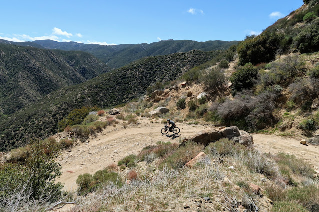


The day’s miles were ticking by nicely until we reached Vallecito Creek. Ana learned why the Cholla Cacti are called “jumping cactus,” and there began our ill-fated affair with sand.


Once we hit Diablo Drop, we were really in the thick of it. Literally. We had initially planned to do a bit longer of an out-and-back along Fish Creek Wash to see the wind caves, but after about an hour of slow going, and reaching the tail end of daylight, neither one of us could even fathom the idea of willingly going more miles than absolutely necessary along the wash. So we set up camp, and called it a night.


Day 2: Fish Creek Wash to Tamarisk Grove, by way of Hapaha Rd and all the sand in the desert

We expected sand, but we didn't expect 6 hours to get 7 miles thinking we might die in the desert kind of sand. This is where we developed our patent pending “Full Desert Mode”: Helmets off, Buffs up, headphones in, no talking. It’s only weird if it doesn’t work. The thing about sand (at least this time of year) is that if untouched by vehicles, it's actually pretty rideable.

There would be stretches of Fish Creek Wash that were wide enough to still have hardpacked edges. Riding on the edges required navigating around cacti and other scrub brush, but it gave us short respites where we were actually able to pedal our bikes. Then the canyon would narrow, and we'd be forced back on to the churned-up jeep tracks where we'd be back to pushing. (Both of us had 2.6 tires, for those wondering).


We eventually found our way onto solid rock, and shared the trails with some Jeeps that were crawling up these insane rock faces (we had an easier trail to hike around the features).

We’ve always had very friendly interactions with people of the motorized recreation persuasion, and this trip was no exception (other than cursing their sand-chewing vehicles all the way up the wash). Everyone was super courteous and just happy to be out doing what they enjoy. We also got the chance to follow one of the rules we learned in our Death Valley Trip: You never turn down a water hand up in the desert (even during a pandemic). We had a couple of "Jeepers" share fresh water with us and make sure we had everything we needed. While we would have (probably) been fine with our planned water supply, it is a nice peace of mind getting a top-off half way through the desert. The irony? If the Jeeps weren't around to churn up the sand, it wouldn't have taken us so long to get up Fish Creek Wash, and we probably wouldn't have needed their water...


Hapaha Road meets up with Highway 78, and while our route had us heading back into the desert to Tamarisk Grove campground, rather than risk another sand trap we decided to detour along the highway for a few miles. The pavement was a welcome break. At the dispersed/overflow camping of Tamarisk Grove we had the place to ourselves and spent the evening watching a storm blow through the desert below us. Maybe the rain would pack the sand down for tomorrow’s ride?


Totals (numbers do not accurately reflect the hours of suffering): 34 miles, 3,700 ft. elevation
Day 3: The Willows!
But before the willows were desert sculptures, burritos, blooms, and a (very dead) bighorn sheep.


Ana swears that every restaurant with “-bertos” in the name is actually part of a giant network owned by a family in Arizona. Adam’s pretty sure if that’s true the owner’s name is probably Gustavo Fring.

Burritos consumed, a parking lot yard sale and resupply packing game of Jenga, and new fuel canister obtained (because someone made an error in his cooking calculations - thank you Borrego Springs hardware store!), it was back to the desert.


“The Willows” is about an hour walk up a stream surrounded by, you guessed it - willows! It is an actual trail, which begs the question of what's outside of that section that's worse?! We made it to Bailey's Cabin that night just before pitch dark, but unfortunately there was already a group inside so we didn't get to check it out (or sleep inside as we had been dreaming of). For the record, we'll take an hour of pushing through water over sand any day!

Totals: 42 miles, 2800 ft. elevation, 2 burritos, 1 giant pile of fries, and 6 very wet shoes (bad decisions were made at the first water crossing).

Day 4: Big skies and big climbs
Our last day was by far the biggest in numbers, but since we were mostly done with the sand it didn't feel nearly as soul crushing. It was just regular hard.
As we made our way up and out of Coyote Canyon, the storm clouds were growing, but we never saw more than a few sprinkles. Having a few friends riding the full Stagecoach route about a day behind us, we were wondering if they were in the middle of the storms (turns out a few were). Descending down into the green side of the mountain was a welcome sight; the consistent headwinds were less welcome. The plan for the day was to just keep moving. We had a lot of ground to cover and dwindling food supplies, so the goal was to get back to Julian before the restaurants closed for fear of dinner being whatever bars we’d been putting off eating the last four days. We were back on another glorious section of the California Riding and Hiking Trail through the Beauty Mountain Wilderness study area, and holy heck is it really beautiful!


We went through a variety of landscapes and ecosystems, and Adam even spotted a bobcat! Descending down through Cleveland National Forest, we passed through a large controlled burn operation in preparation for another exciting fall in California.
The gas station ham sandwich at Warner Springs was a perfect pick me up for Ana, and Adam took the healthy approach with Ruffles, sunflower seeds, and Skittles. Warner Springs is also a stop for hikers on the PCT, so the woman at the register was used to stinky people, and eager to hear all about where we had been and where we were headed. At the suggestion of a stranger on Facebook (because that's where we get all our hot tips), we got off the highway leading straight to town and hit some bonus dirt (and climbs) through the Santa Ysabel Preserve, making it back to Julian just before sunset. Thankfully the Julian Beer Company was still open, so we were able to have barbeque sandwiches for dinner instead of slightly smooshed Clif bars. And yes, we did come home with two delicious pies from the Julian Pie Company!

The gas station ham sandwich at Warner Springs was a perfect pick me up for Ana, and Adam took the healthy approach with Ruffles, sunflower seeds, and Skittles. Warner Springs is also a stop for hikers on the PCT, so the woman at the register was used to stinky people, and eager to hear all about where we had been and where we were headed.


(Don't say we didn't warn you)


Sweet adventure guys. Those are some big days. Looks like I need to get some serious training in to keep up with you on the OTT
ReplyDeleteThanks! But don't mistake big days for high speed ;) haha
Delete<3 another great adventure! Thanks for letting us non-cyclists live vicariously through your fun, Types I II and III included :)
ReplyDeletehaha Thanks Sarah! :)
DeleteI love following along, thanks for doing the write up!
ReplyDeleteThanks Amanda!
DeleteI loved all of this. Ana is correct about -bertos lol
ReplyDeletehahaha I just saw this!! Thank you for agreeing with me! ;) Good to see you today <3
Delete