Hey Joe Safari
A note on timing: We were both lucky, and unlucky, depending how you look at it. While we got in an amazing adventure under the wire, it became clear we needed to cut it short, and we're now writing this while sheltered in place at our home, in Santa Rosa, CA. Now is NOT the time to head into the unknown. For the sake of small towns who support these adventures, please, stay at home, and start planning for when we're all released back into the wild.
 March 13, 2020
After months and months of planning, packing, buying, researching, and mentally preparing for tackling the Stagecoach 400 route over spring break, the worst weather in recent history in the greater San Diego area for mid-March arrived. Since we weren't planning to participate in the actual event, we decided to make a last minute change of plans, and chase some sunshine in Utah.
While there are a handful of what look like great routes listed on bikepacking.com, we decided to go with the Hey Joe Safari in Moab. 100 miles, 100% dirt, with a little hike-a-bike scramble, sounds great!


 At one point we tried unpacking part of Adams bike, carting that down a few ledges before bringing the bike down, but that seemed to be more hassle than it was worth. It also didn't help that this was the section we tried to follow our new friends down, which was much more challenging than the actual route. From then on we agreed to follow our own path down.

Some of our favorite moves...


 Even though you're meandering along an enormous river, the water stays just out of reach. Plus, it is extremely silty, so not advised to try and filter unless absolutely necessary. Luckily there was a fresh, clear stream just as we started making our way out of the canyon. We filtered one bottle, and began the climb out. Our second water cache and a camp area was about 13 miles ahead at the top of the canyon.


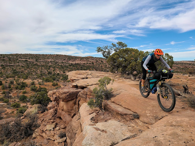
 What they failed to mention, is that the Mag 7 trails are some of the most fun loaded-down singletrack I've ever been on! Winding first through high desert pastures, then into red rock and techy sections, and views for days, and overlooks, it was amazing! Until my saddle rails both snapped.

The final climb up Gemini Bridges Rd was a final ass kicker (maybe because I couldn't actually sit on my saddle), but the view overlooking the valley, and the towering red rocks was a good reminder of why tourists come from all over to this area.

Route totals: ~103 miles and 7,100 ft elevation gain. 3 days, 2 nights.

Wishing everyone reading this good health and a safe next few months. How sweet it will be when we can get back out there. - A&A


After months and months of planning, packing, buying, researching, and mentally preparing for tackling the Stagecoach 400 route over spring break, the worst weather in recent history in the greater San Diego area for mid-March arrived. Since we weren't planning to participate in the actual event, we decided to make a last minute change of plans, and chase some sunshine in Utah.

The week before we left, things with COVID-19 were starting to heat up in the US, but no further warnings other than "wash your hands" was really being published. So, Friday after school we finished packing the car, and headed out of town. More on the epidemic later. At best, it's about a 15 hour drive. There was a storm looming in the Tahoe area, so our only goal was to get past Reno. We stayed over night somewhere in Nevada, and drove all day and into the night on Saturday to Moab.

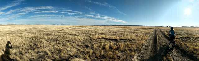
Before heading to our camp/parking spot for the night, we dropped water at two water caches for our route (see Hey Joe link above for info). They were super easy to access by car, and did not add much extra driving time (highly recommended if doing this route). Saturday night we camped on Willow Springs Rd. (BLM land with dispersed camping facilities), which is right along the route so it makes for a perfect starting point. After driving around in search for an open place to camp, it was clear that we weren't the only ones with dreams of a spring break in Moab.

Day 1: Willow Springs to just before The Sand (30 miles, 2,000ft elevation gain)
Featuring; Dino Flow!
It took us longer than expected to get all of our bikes packed up and ready to roll, so we didn't end up leaving camp until close to 1pm. Luckily, the folks camping next to us had a Jack Russell to keep us entertained...

The first day was fairly uneventful and pleasant. Willow Springs area sees a lot of moto activity, so we started with some thick sand, but it didn't last long and we were into the Sovereign trail network. We stayed mostly on fire roads, although it criss-crossed over singletrack. Not wanting to go off-route immediately, we stuck to the plan. But, it seems like that area has some pretty good riding, and you could probably modify the route to stay more on singletrack there. Even in the first few miles we got to sample some classic Moab slickrock and views into Arches National Park, a great way to start the adventure.

After about 12 miles, we made it to the Klondike Bluff trail system. We took a trail called Dino Flow, and it was amazing! Super fun singletrack that was totally doable loaded down. And, it seemed to go on FOREVER. We ran into only a few people on the trails (while maintaining our social distancing), and at the end of the singletrack we were rewarded with seeing a couple different sets of dinosaur tracks, which was dino-mite.

 |
| A sauropod dinosaur tracks (what look like giant post holes) dot the ground under my bike. |
 |
| Allosaurus tracks. |
The rest of the miles were on beautiful, winding dirt roads, spotted with campers every so often. Just before crossing Highway 191 we were given the option to ride a frontage road, with a wire fence crossing, or ride on the highway. We chose the former.

However, the wire fence is fairly tightly strung barbed wire, and tall enough that passing 60 pound bikes over the top was not an option. Thankfully Adam's persistence in finding a good way through the fence paid off, and found a cut in the fence on one of the sections where it was pretty clear people used it like a gate. It was only one of the three wires, but after finding a cardboard box for "protection" it was just enough to squeeze us and our bikes under. We'll be pros next time we have to cross a border.

After crossing the 4-lane highway of super trucks, and very glad we didn't have to ride along it, we were at our first water cache. Onward into the high desert! Save for the woman permanently camped in seemingly the middle of nowhere, with her pack of (very well behaved) dogs who initially scared the crap out of us, we saw only cows the rest of the ride. Oh, and an alpaca who wanted nothing to do with saying hi. It looked like it had rained maybe a few days prior, and judging by the ruts in the road, you would not want to attempt this soon after a rain (or in the rain).


By about 6pm with the sun setting, we decided to turn down a dead end road and set up camp. We had a delightful meal of freeze dried chicken pad thai (Backpacker's Pantry - highly recommended flavor) went to sleep with the Milky Way wheeling above us and listening to coyotes yipping in the distance.

Day 2: The Sand to Lone Mesa camp (~40 miles, 3,100 ft elevation gain)
Featuring; The Sand, Hey Joe Canyon scramble, and climb out of Green River/Spring Canyon
We woke up to condensation in our tent, and frost on our bags. My Garmin read 37-degrees at 8am. We took our time getting up, partially waiting for the sun to pop over the ridge to dry everything off. We rolled out of camp around 10am and rode through more miles of high desert farmland, eventually catching sight of red rock formations. This is when we hit "The Sand."

We had been warned about this, but riding in sand, fully loaded, is no great pleasure. My bike was setup 29x2.6 and Adam was setup with 27.5x2.8 - I cannot imagine riding this section with much less than that. Our entertainment for the next couple hours was following recent bike tracks, and then footprints walking next to the bike tracks, which helped us feel a little less lonely out there. Because, at least someone else had to walk their bike, too. We fondly started referring to the tracks as "Five Tens" and "Minions." A few packs of friendly motos passed the opposite direction, and it looked like the sand was pretty tricky for them as well. Hopefully they didn't have to hike-a-bike!

Slowly, the sand began to give way to rock, and we found ourselves on some beautiful red rock formations, which is where we caught up to our friends, Five Ten and Minions! We felt like we had found old friends, while they looked at us like rare desert monsters. They were stopped for lunch, so after chatting for a minute we continued on, joking that we'd probably see them again at the hike-a-bike section.

With only a couple more miles of off-and-on sand to contend with, we finally reached a real (dirt) road, with motos and 4-wheelers whizzing by. From this high vantage point we could see clear across the desert to where we had come from, and glimpses of the canyon we were headed towards.

Twisting across BLM land with views that go on seemingly forever, we finally reached the edge. And yes, that cairn was leading us straight over it.

Adam doesn't always handle rock scrambling and serious exposure too well, and leading up to this section he joked that he would put on his big boy pants when the time came. Neither of us realized just what we were about to endure. The first few ledges were manageable after scouting our best routes down, and having to think carefully about dealing with 60 pound bikes. Adam changed into some more rock-worthy shoes (I was already wearing shoes with a grippy sole), then, soon after, Five Ten and Minions reached the ledge above us. They made their way quickly to where we were scrambling along, and it became clear that their setup - a load in a backpack rather than on their bikes - would be far superior to managing this section.


Following the cairns was key to our success, although sometimes they were a little unbelievable. Hey Joe Canyon is a 1,000 foot drop straight down slickrock to the river. Imagine the beautiful towers of Sedona, rising straight up into the sky...that's what we were going down, with our bikes. Photos do not do it justice, mostly because during the most tricky parts there was no way to document it. I wish I had been wearing a GoPro. We quickly realized we would need to work together to navigate each bike down, only to go back up to get the second.
 |
| We started at the top. |
Some of our favorite moves...
- The Hand-Off: This worked well for overhangs of human height. Adam could reach up and hoist the bike down. (Typical, class 1 maneuver. Watch your step).
- The Hail Mary: Used in the type of terrain you imagine when you hear, "tricky hike-a-bike." Because I have a long stride (also known to some as femuritis), it is easy for me to jump across rocks, or take large steps down. Usually there is a moment of being totally out of control with the bike, but hoping it will take the intended line down and stop at the bottom next to you. (Typical, class 2 maneuver. Height advantage).
- The Rear Wheel Scoot: This worked well in places where I had just enough footing to walk/crouch next to the bike, using the brakes for balance, but on such steep pitches the bikes would threaten doing their own endo. So, Adam would follow behind, holding the rear wheel, and scooting along acting like an anchor. (Used most often on this traverse, class 4 maneuver. Would recommend).
- The Horizontal Shuffle: This was an emergency procedure, reserved only for the trickiest bits with little to no footing, and a long distance to the next ledge. With the bike parallel to the cliff, one person was in charge of the front wheel, one on the back, both on their butts/heels with bike leaned onto our laps, slowly shuffling down to the next ledge. (Invented by Adam, class 5 maneuver. Hope to never do again).
All in all, this 1,000 foot endeavor took us 4 hours from rim to river. Our friends in front of us took about 3 hours, and we saw them ride off into the distance as we were still hanging from the edge of the cliff.

Once down, we passed abandoned uranium mining equipment (maybe there was a miner named Joe? Need to research the name), and made it out of the canyon to the Green River. A beautiful trail stretches for miles along the Green, which lulled us into thinking maybe this would be a good place to camp for the night, given that it was getting close to dusk. Until we passed the freshly picked bones of a cow. The decision was made, for me, that I wanted out of that canyon.


While the climb out on Hey Joe Canyon Safari Rte. was tough, it was still all very rideable, especially with some tunes, and motivation from large kitty tracks (that were probably from a domestic dog, but of course I'm still imagining the cow carcass)...and that view into Spring Canyon at the top!

We decided to keep riding after dark because we were still feeling pretty good, and the temperature was perfect. The day before had been pretty windy, so we felt like savoring the calm air.

We rolled into Lone Mesa camp around 9pm, set up the tent, cooked dinner (which included the salami we never ate for lunch), and slept hard.
Day 3: Lone Mesa and singletrack (~31 miles, 2,000 ft elevation gain)
Featuring; The best singletrack and broken saddle rails
Featuring; The best singletrack and broken saddle rails

After picking up our water cache near the campsite, we only went a handful of miles before diving onto singletrack. THIS was the highlight of the whole route. They were not lying when they said 20 miles of beautiful singletrack.


I limped through a few more miles of bouncy singletrack, but it was clear that I should take it easy if I wanted to not be carrying my saddle pack under my arm for the last 10 miles of our route (VERY thankful that it did not happen earlier in the trip!). So, we took a turnoff that put us on a fire road, and skipped maybe the last 2 miles of singletrack. Having to either stand or put slight weight only on the nose of my saddle made for a challenging last few miles, given that my legs were toast, but it was manageable, and I didn't have to walk it in.
The final climb up Gemini Bridges Rd was a final ass kicker (maybe because I couldn't actually sit on my saddle), but the view overlooking the valley, and the towering red rocks was a good reminder of why tourists come from all over to this area.

We crossed back over Highway 191 (this time without a fence), wound through more open grazing pastures, and made our way back to the car. Totally spent, and totally happy.
Route totals: ~103 miles and 7,100 ft elevation gain. 3 days, 2 nights.

Coming back into a pandemic
While we were blissfully off the grid for 3 days, the COVID-19 pandemic was unfolding in the U.S. When we got back into service, we first saw a message from a friend, stating that Moab was closing all hotels and camping. We were able to book a room for that night only (again, thankful on timing), but the coming days which we had planned to camp and spend exploring the real mountain biking of Moab were clearly going to take another shape, or be cancelled. Thinking that we might be able to sneak in one more ride, I needed to find a saddle ASAP, but all the stores were closed due to Coronavirus. Thankfully, someone answered when I called The Rim Cyclery and allowed me to run in and buy a saddle - from a safe distance of course.
With a storm headed in the following evening, we decided to spend the morning in Arches, and after lunch got in a quick mountain bike loop on the MOST FUN trails at the Moab Brand trails. We finished loading the bikes back on the car right as the deluge began.
After reading this article, we realized not only how serious the COVID-19 epidemic was becoming, but also how much tourists needed to stay out of small towns. News from home told us they were implementing "shelter in place" orders, and all shops and restaurants were shut in Moab, save for takeout. Having most of the food we needed already with us, we did our best to tread lightly on the communities we found ourselves in.
 We stayed one more night in Monticello, about an hour outside of Moab, and got on the road early the next morning (in the snow - we had no idea we were all of a sudden at 7,000 feet!).

The bikepacking loop was just the adventure we had been craving, and after my small sampling of Moab singletrack, I can't wait to get back there when the world goes back to normal.

All photos copyright Ana Pimsler & Adam Havner, 2020
Awesome. Did you hire a professional photographer for your trip????
ReplyDeleteHaha thanks! Because it says unknown author, I'm guessing this is a friend giving me a hard time... (But in case it's not, no, photos are all ours ;)
DeleteI finally read this, what a crazy adventure! Look forward to hearing about it in person...one day...!
ReplyDelete